 05:23
05:23
 homesweethome

Giza Pyramids
Giza (Arabic: الجيزة Al J(Ǧ)īza), sometimes spelt G(J)izah, is the third largest city in Egypt. It is located on the west bank of the Nile River, some 20 km (12.43 mi) southwest of central Cairo. Along with Shubra El-Kheima, Cairo and Helwan, the four cities form the Province of Greater Cairo metropolis.

The city of Giza is the capital of the Giza Governorate, and is located near the northeast border of this governorate in coordinates. It is located right on the banks of the River Nile. The city's population was 2,681,863 in the 2006 national census, while the governorate had 6,272,571 at the same census. Its large population makes it the second largest suburb in the world, tied with Incheon, South Korea and Quezon City, Philippines, second only to Yokohama, Japan.

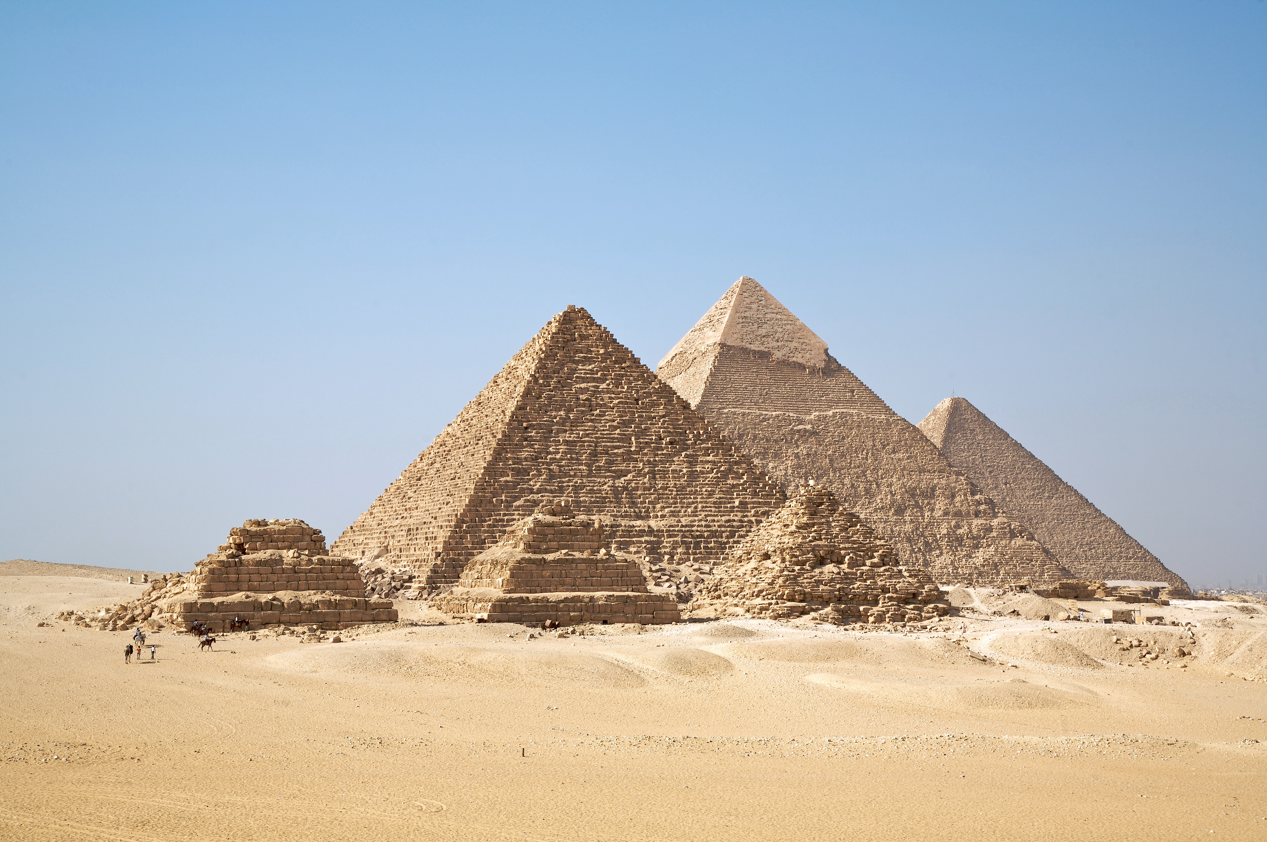
Giza is most famous as the location of the Giza Plateau: the site of some of the most impressive ancient monuments in the world, including a complex of ancient Egyptian royal mortuary and sacred structures, including the Great Sphinx, the Great Pyramid of Giza, and a number of other large pyramids and temples.

The plateau and its monuments have been recorded in the Giza Plateau Mapping Project run by Ancient Egypt Research Associates, directed by Dr. Mark Lehner. AERA's 2009 field season was recorded in a blog.
The Great Pyramid of Giza at one time was advocated (1884) as the location for the Prime Meridian, a reference point used for determining a base longitude.

History
"Mn Nefer" (Memphis, in Greek) - which means "the beautiful wall" in the ancient Egyptian language -, the capital city of the first unified Egyptian state since the days of Pharaoh King Narmer, lies nearly 20 km (12.43 mi) south of Giza.

Giza's most famous archaeological site, the Giza Plateau, holds some of the most astonishing monuments in Egyptian history. Once thriving with the Nile that flowed right into the Giza Plateau, the pyramids of Giza were built overlooking the ancient Egyptian capital city of Memphis, which was near modern day Cairo.

The Giza Plateau is also home to many other ancient Egyptian monuments, including the tomb of Pharaoh Djet of the First Dynasty, as well as that of Pharaoh Ninetjer of the Second Dynasty.

Climate
Giza experiences an arid climate (Koeppen BWh), but often with high humidity due to the Nile River Valley's effects. Wind storms can be frequent, bringing Saharan dust into the city during the months of March and April. High temperatures in winter range from 12 °C (54 °F) to 17 °C (63 °F), while nighttime lows drop to below 7 °C (45 °F), often to 5°C; the lowest recorded temperature was 0.8 °C (33 °F). In summer, the highs rarely surpass 40 °C (104 °F), and the lows drop to about 20 °C (68 °F). Rainfall is sparse, but sudden showers do cause harsh flooding. Hail and sleet might take place.


Giza Necropolis
The Giza Necropolis (Arabic: جيزة يسروبوليس) is an archaeological site on the Giza Plateau, on the outskirts of Cairo, Egypt. This complex of ancient monuments includes the three pyramid complexes known as the Great Pyramids, the massive sculpture known as the Great Sphinx, several cemeteries, a workers' village and an industrial complex.

The Giza pyramid complex at night
It is located some 9 km (5 mi) inland into the desert from the old town of Giza on the Nile, some 25 km (15 mi) southwest of Cairo city centre. The pyramids, which have always loomed large as emblems of ancient Egypt in the Western imagination, were popularised in Hellenistic times, when the Great Pyramid was listed by Antipater of Sidon as one of the Seven Wonders of the World. It is by far the oldest of the ancient Wonders and the only one still in existence.

Giza pyramid complex seen from above


 Posted in: EGYPT


0 意見:
Post a Comment